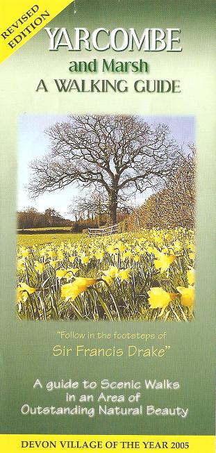
A
Guide to Scenic Walks in an Area of
Outstanding Natural Beauty
|
This leaflet - the printed
equivalent of this web page - can be
found in many local shops and public
houses. |
|
Using the Footpaths
Our footpaths
and bridleways, which today are public
rights of way, have been used by generations
of local people going about their daily
work. More recently they have
become a source of pleasure to both local
people and visitors, who enjoy walking in
the beautiful Devon countryside, but please
remember that though these paths and tracks
are part of the public highway system, they
are owned either by individuals or by
organisations, and are generally on
farmland. Owners are welcome to
take dogs with them on walks, but the
animals must be kept on a lead or under
close control, especially in areas where
farm animals are present. No
special arrangements are made to enable pets
to negotiate stiles or other natural
features.
Please stay on the marked paths, close and
secure all gates behind you, keep away from
cattle, crops and machinery, and take your
litter home. Do take care of our
paths, which are maintained both by Devon
County Council and by a group of
unpaid volunteers from the Parish.
Enjoy your walk.
About The Walks
This information offers the walker
suggestions for a choice of walks of varying
lengths in this Area of Outstanding Natural
Beauty (AONB), using marked Footpaths (red)
and Bridleways (green), over land once owned
by Sir Francis Drake. Each
Footpath or Bridleway is marked with the
Footpath or Bridleway number, and these
numbers are also shown on the map.
'Waymark Arrows' (yellow on a green
background), are provided in suitable places
to indicate the direction of the path.
The walks start from the Yarcombe (Jubilee)
Village Hall which is
situated
behind the
Yarcombe
Inn in the centre of the village about 60
yards from the A30 road. There
is free parking here, although a donation to
the Hall funds would be appreciated, for
which purpose there is a letter-box slot in
the Hall entrance door!
We do ask that cars be left in that part of
the car park behind the Hall, rather than in
the front car park. (From the
front car park, drive down the narrow access
immediately to the right of the Hall
entrance). You may of course
start your walk at any convenient point, but
please take care not to block narrow lanes
or gateways if leaving vehicles other than
at the Hall. Please do lock your
vehicle and make sure valuables are kept out
of sight. You may also wish to
decide on a different walk yourself, using
the map as a guide.
Devon is geographically a county of hills
and valleys, and several of the walks should
be noted as 'steep in places', and thus are
not suitable for those with a significant
disability. It is strongly
recommended that even the physically fit
wear suitable footwear to cope with wet and
sometimes muddy and uneven ground, and also
take with them wind or shower-proof
clothing, to ward off the cool breezes, when
the weather is less clement. The
magnificent panoramic views will reward your
exertions.
Distances and times shown are only
approximate. There are no public
toilets available, other than for customers
at the Yarcombe Inn.
Note however that the Yarcombe Inn
is currently closed, although this may
change soon. Until then, the
building may not be immediately identifiable
as the signs have been removed. |
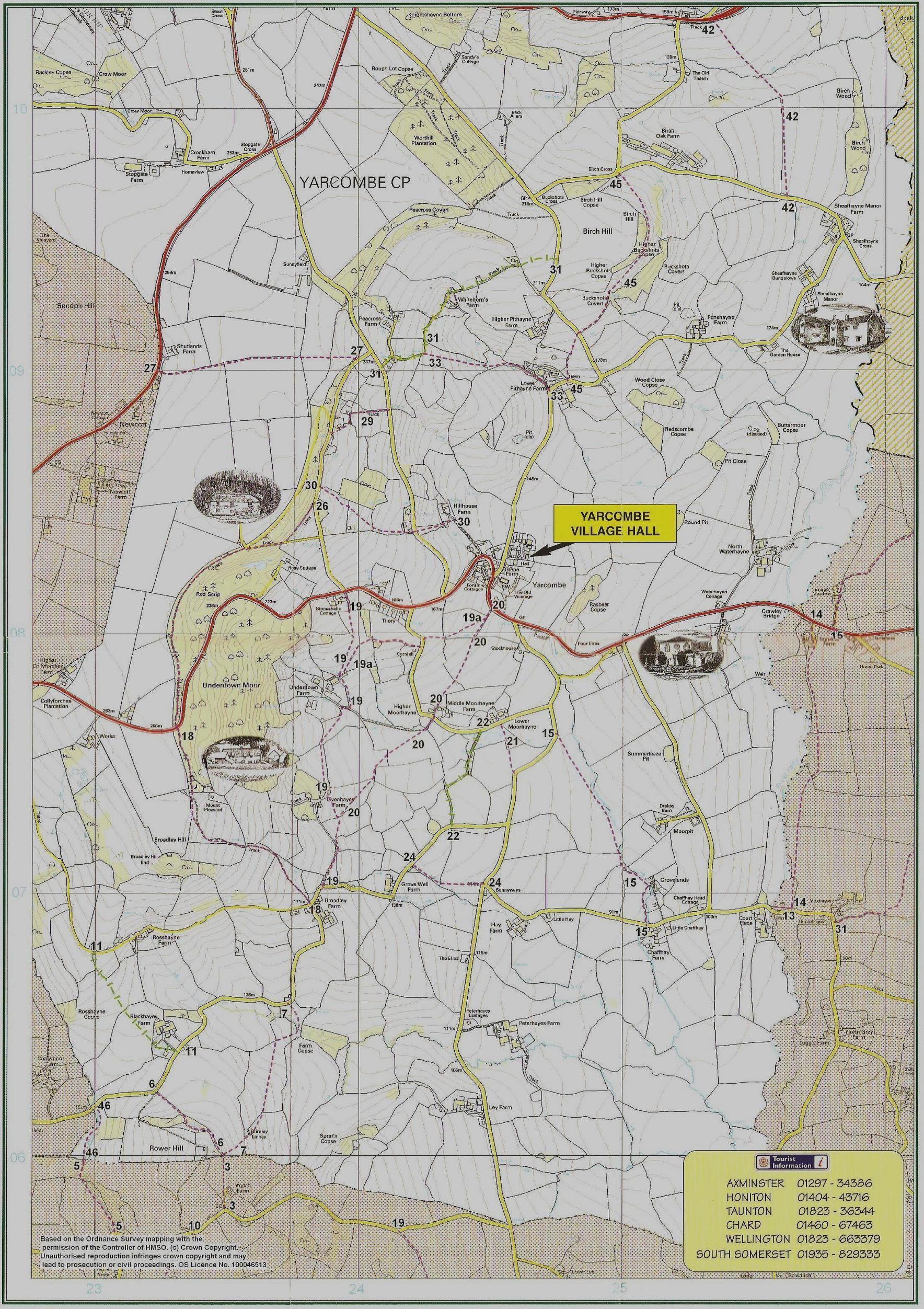
Walk 1
An easy walk through open
fields with valley views. About
3� miles or 1� hours.
From the Hall car park, turn left and walk
up to the A30 road. Turn left
again and walk downhill past the
Yarcombe
Inn public house for about 100 yards, before
turning right into a track at the start of
Footpath 20. Cross the
stile and follow the hedge line.
Ignore the first stile on your left (which
marks the continuance of Footpath 20), but
continue following the hedge line, now on
Footpath 19A, until reaching a wooden
sleeper bridge. Cross the bridge
and its associated stile and in front of
you, across the field, you will see another
stile leading onto Moorhayne Lane.
Turn left down the lane then almost
immediately right onto a narrow path just
above the house known as Cornhill.
Having crossed another stile, keep the hedge
on your left and walk along the field.
Go past the first gate on your left but go
through the next, which is a few yards
further on, and turn half left, heading
downhill towards the farm buildings of
Underdown Farm. This is the
end of Footpath 19A and the start of
Footpath 19.
Go over a stile and turn sharp left, through
a gate and over another stile into a field,
leaving the garden hedge of the farm on your
right. Go through the pedestrian
gate at the bottom of the field and turn
right onto the farm drive, and after about
30 yards, turn left and over another stile
into a field. Follow the hedge
for about 50 yards, to the corner, from
where looking to your right, you will see a
gate in the far corner which you should go
through, and head towards the barn above you
at Livenhayes Farm. Walk
through the farm buildings and leave the
yard by way of a further gate straight in
front of you. Walk straight
ahead down the field, through another gate
and then turn half right, heading steeply
uphill towards a stile, and the farm
driveway. Turn left along the
drive; go through the gates to the road and
the end of Footpath 19.
Turn sharp left down the lane towards
Grove Well Farm. Leaving the
buildings on your left continue for about
100 yards to the cottage known as
Grovelands on your right.
This marks the start of Footpath 24.
Turn right, cross the stile and follow the
hedge down the field to a pedestrian gate
and stile. Walk ahead across the
field towards Sunnyways bungalow on
the far side. Cross the stile
and the road to Stockland, and walk down the
lane opposite past Hay Farm and
Little Hay to Chaffhay Farm.
On your left, immediately before the
buildings is the start of Footpath 15.
***Go over the stile and cross the
first field diagonally, to the far left
corner. Walk into the copse and
then follow the waymark arrows, keeping the
stream on your right. Having
crossed two bridges follow the stream until
the large field narrows, when you will see a
gate on your left - this exits onto the
Stockland Road.
Go through the gate and turn right,
following the lane back onto the A30 road.
Here, turn left and walk uphill back to the
Yarcombe Inn and the Hall.
***Alternatively continue on past
Chaffhay Farm to the top of the hill and
turn left at the junction. You
may then walk along the ridge road, admiring
the views to each side, before reaching the
Baptist Chapel on your left and the A30
road. Turn left and walk about
20 yards, before turning left again down a
narrow lane which leaves the forecourt of
the group of houses. This is Rag
Lane and it will return you to the Stockland
Road and the pub and Hall.
Walk 2
A long gentle climb to a high
point which gives commanding views of the Yarty Valley. About 3 miles, 1�
hours.
From the Hall car park turn right into the
lane and walk away from the main road
towards Lower Pithayne Farm.
Ignore Footpath 33 at the bottom of
the hill near the farm, but walk up to the
tractor barn where opposite, at the top of some stone
steps is the start of Footpath 45.
Climb the stile here and follow the
direction of the finger post across the
field until you reach another stile which
gives onto a lane. Cross both
this stile and the one on the opposite side
of the lane, and walk ahead across the
meadow towards a gate on the far side, to
the left of a copse. Having
passed through the gate, walk diagonally
uphill to another copse on the brow, and
keeping this on your left, follow it round
until reaching an open field.
Leave the copse tangentially and walk
forwards, down over the brow towards a gate
which you will be able to then see, and
the end of Footpath 45 at Birch
Cross. Turn left here, walk
up the lane towards the T-junction of
Buckshots Cross and turn left again, up
the steep hill and over the brow until
reaching Bridleway 31 on your right
hand side. Turn right into the
field and walk straight ahead towards a gate
on the far side of the field.
Then follow the field boundary downhill,
leaving the stone barn on your right, until
you reach another gate leading onto a grassy
track to Whitehorn's Farm on your
left hand side. Then follow the
house drive uphill passing the end of
Footpath 33 on your left, until you
reach the link road which joins the A30 road
with the A303. From here you
will have a magnificent view of the whole of
the River Yarty valley. ***Turn
left here and walk downhill to the A30.
Take care in crossing the road at this point
and continue downhill on the footpath until
reaching the lay-by where you will find a
seat, another splendid view and an
Orientation Table showing the direction and
distances to various local features.
A further short downhill walk returns you to
the lane leading back to the Village Hall.
***Alternatively, turn right uphill,
take the first lane on the left and walk
along the contour under the wood until you
reach Footpath 30 on your left hand
side. Cross the stile and follow
the waymark arrows down through the wood to
a gate at the lower right hand side.
Walk straight ahead to another gate which
can be seen opposite. Go through
it, cross the link road, down the steep
rutted track to the driveway of Hillhouse
Farm. Turn right and follow the
drive back to the A30, emerging just above
the turn to the Village Hall.
Walk 3
A walk across easy open
fields and then a steep climb to Rower Tower
and spectacular panoramic views.
About 4 miles or 2 hours.
From the Hall car park, turn left and walk
up to the A30 road. Turn left
again and walk downhill past the
Yarcombe
Inn public house for about 100 yards,
before turning right into a track at the
start of Footpath 20.
Cross the stile and follow the hedge line to
a stile on your left. Cross this
stile and walking ahead and slightly to your
right, head for a gate into another field.
From here walk through another gate between
the buildings known as Higher Moorhayne
& Middle Moorhayne Farm.
Cross the lane and walk straight ahead up
the driveway opposite. In front
of you is a stile. Cross this
stile and walk diagonally right in the
direction of the farm buildings which can be
seen on the hill slope ahead.
Cross another stile and follow the hedge
line around to the left and go through the
gate at the corner of the field.
Ignoring the gate immediately on your left,
follow the left hand hedge line, still
walking gently uphill until reaching yet
another gate. Go through this
and then head diagonally right, steeply
upwards to a stile, and exit onto the farm
driveway and turn left. You are
now on Footpath 19.
Follow it through the gates to the road and
the end of Footpath 19.
Walk slightly uphill to Broadley Farm
and turn left at the T-junction.
Walk down the lane for about 400 yards until
reaching a bungalow on the right hand side.
Opposite is the start of Footpath 7.
Walk down through the field to the stream at
the bottom, and turn sharply right over the
smaller concrete bridge into an ungated
field. Walk up to the wire
fence, go through a gate into another field
and from there, looking ahead up the length
of the field, you will be able to see a
substantial barn known as Brimley Linhay.
Heading towards this building, leave the
field through another gate and then with the
Linhay on your right, continue steeply up
the hill through another gate to the top
left hand corner of this field.
Here the route divides, but we shall turn
right onto a grassy track, leaving
Footpath 7 and continuing on to
Footpath 6. There is a
splendid view from this point.
The grassy track marks the start of
Footpath 6 which travels along a contour
of Rower Hill beneath Rower Tower, a
local landmark. Follow the path,
past the pond, eventually descending towards
a field gate. By passing through
the gate and walking downhill, keeping the
hedge line on your right, you will emerge
onto a surfaced road, and will have reached
the end of Footpath 6.
Turn right towards Blackhayes Farm,
and the start of Bridleway 11.
Go into the farmyard, (ignoring the drive to
the house) and passing the duck pond on your
right, leave the farmyard by way of a gate
and walk straight ahead across the field,
passing through two further gates, climbing
towards the minor road near Rosshayne
Farm, and the end of Bridleway 11.
Turn right and follow the road back past
Broadley Farm to Footpath 19,
from where you may retrace your steps to the
Hall.
Walk 4
A steep climb then a walk
along a wooded ridge to panoramic views of
the Yarty Valley. About 3 miles
or 1� hours.
Turn left out of the Hall car park and walk
up to, and cross the main road, (care
needed) on to the pavement.
Continue up the hill around the sharp left
hand bend to the lay-by. Here
there is a splendid view of the whole of the
Yarty Valley, and an orientation table
identifying local landmarks.
***From here continue up the hill a
little way, before crossing the road (care
needed) into the link road (signed to
Taunton) which joins the A30 with the A303.
Walk uphill until reaching the first house
on the left, known as Winnowing Knapp, and a
Footpath 30 sign on your left.
***Alternatively, from the lay-by,
retrace your steps to the sharp bend and
cross the road (care needed) into the
cul-de-sac lane, following the Footpath
direction sign to the driveway entrance of
Hillhouse Farm. Here turn
sharply left onto Footpath 30, up the
steep and rutted path to the link road.
If you have come from Hillhouse Farm, cross
the road, or if you have come from the A30,
turn left and go through the gate into a
field. Following the footpath waymark arrow walk straight ahead, across
the field, through a second gate into a
copse. Follow the path
diagonally right, looking out for further
waymark arrows as you go through the cleared
shrubs up to the top right hand corner of
the copse. The stile here marks
the end of Footpath 30.
Turn left onto the surfaced road, known as
Beacon Lane, and after about 60 yards fork
right, through another field gate onto
Footpath 26.
Walk along the top edge of this field until
you emerge onto a loose-surfaced track.
Turn right and go uphill until you reach the
summit of the climb, in the woods.
Then turn sharply left off the track and
walk along the flat ridge on a grassy path.
After some 800 yards you will reach the A30
road which must be crossed at a sharp
corner, at the end of Footpath 26.
(Much care is needed here, there being
very little visibility in either direction.)
You are now at the start of Footpath 18,
so continue through the gate and the trees
to a further gate into a field, ignoring a
private track which leads down to the left.
As you negotiate the gate, take a moment to
admire the remarkable view down the Yarty
valley towards the sea. Follow
the track downhill, go through another gate
and continue down to the surfaced road at
Broadley Farm, which marks the end of
Footpath 18.
Turn left down the lane, leaving Broadley
Farm on your right and after about 100
yards where the road turns sharply right and
descends, fork left and go through the gate
onto a track. This is the start
of Footpath 19. After
about 200 yards turn right off the track
over a stile and walk diagonally left,
towards and through the gate onto
Footpath 20. Then turn
diagonally right towards the farther of two
gates at the bottom of the field.
Go through the second gate and follow the
right hand hedge about 50 yards to a corner,
before turning half right again, from where
you will be able to see a stile and the
church and village in the distance.
Cross the stile and head towards the houses,
over another stile, before emerging into a
lane at a point where the path passes
between two houses, Higher and
Middle Moorhayne Farm. Pass
between the houses and through a gate into a
field, follow the hedge on your right for
about 50 yards, then go through another
nearby gate which you will see in front of
you. From here head for the
church tower which is just visible on the
skyline. After crossing a
further stile, follow the hedge on your
right to the final stile to emerge onto the
A30 trunk road. Turn left up the
pavement back towards the
Yarcombe Inn
and the car park.
This information has been produced with the
encouragement and support of
Devon County
Council and Yarcombe Parish Council, under
the Parish Paths Partnership (P3) scheme.
Public Rights Of Way Information
|